Little remains of the bridge today, but the walk across Upton Ham is still very pleasant. The old bridge site is probably best reached by walking the Severn Way public footpath alongside the river: unfortunately, I went down on a dreary day with high winds and bad light which even my shiny new camera could do nothing to improve!
The river is surprisingly busy as you leave Upton, and after a mile you pass the southward bend to reach the Water Extraction Plant in Ryall on the opposite bank. Retired river engineer Bill Burton tells me that the plant is better described as a 'raw water intake', where:
'Raw water is drawn from the river by pump and pumped direct to Strensham water treatment works (oddly on the bank of the River Avon!) where it is treated and then pumped again, roughly following the River Avon to supply the areas of Coventry and North Warwickshire (and a few other places on the way).'Not much to see here for someone on the railway hunt, admittedly, but a busy scene nonetheless.

Walking a little further a long the river takes you to a surprisingly industrial scene at Cemex's processing plant, where sand and gravel from the quarry in Ripple is unloaded from the barges onto the wharf.

These shots were taken on a dreadful day in late March, with 40mph winds pushing us back constantly as we walked south down the river. These two pictures may not look like much, but compared to how benign the Severn usually is, the water was fairly choppy!


Further down the river stand the remains of several timber towers which were used to deliver oil to Upton during World War Two. A 2008 report from English Heritage explains:
'Six wooden towers holding vertical pipes were associated with a World War II fuel depot which was supplied by barges from Avonmouth in Gloucestershire. A jetty stood beneath the towers but was demolished in the 1970s or 1980s. The fuel tanks were in the compound 350m to the east, although others probably lie beneath the long mound immediately behind the river-bank. A similar complex is also located just south of Worcester.'The beams are fairly rotten now but feature prominently in a lot of the old photographs of the bridge and its surroundings.


The first glimpse you get of the old bridge comes when the bankside brush clears to reveal the concrete tower that was built directly in front of it. The tower receives a cable across the river from a post on top of the old embankment (shown further down the page). I originally thought this was a telephone cable, but Rupert Chambers subsequently put me right, telling me it is a line for dropping equipment into the river. Bill Burton again has provided a helpful technical explanation:
'The concrete tower is the Environment Agency's Saxon's Lode river flow measurement or gauging station. The cable is for winding out a suspended propeller velocity measuring device to dip into the water at various depths across the river section to be able compute the flow passing through.'One of the best parts of writing this blog is having the chance to learn as I go along: as a proud Malvernian I make no apology for knowing nothing about rivers, so thanks a lot to Rupert and Bill for this information. It's probably just as well that the gauge wasn't out on the day that I took these photos, anyway, as the river was moving at a fair lick!

The concrete tower on the eastern bank stands in front of the remaining arch of the original railway bridge, shown clearly in the next three shots:


The embankment on the western bank itself was cut back somewhat when the bridge was removed. Here, we see the cable support pole sitting on top of the embankment across the river from the concrete tower.
 |
| The end of the embankment is fenced-off behind this gate. |
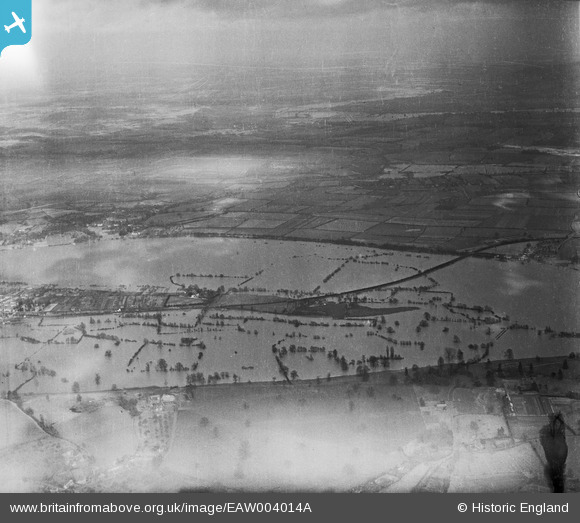 |
| The bridge sitting in the river during the floods of 1947. |
 |
| The view from the foot of the embankment, looking across the Severn. |
 |
| 'Severn Bridge. Upton on Severn, 7.8.61' |
 |
| The end of the embankment. |
 |
| The embankment as it runs back towards Upton. |
 |
| The old route on its way back to Bury End Farm, south of Upton. |
 |
| A final view across the Ham at the embankment. |
Engineering Drawings
The edition of The Engineer from 7th May 1869 featured detailed engineering diagrams of the bridge. The full issue of the journal can be accessed here (courtesy of Grace's Guides), but I've copied the relevant pages below.


hello.
ReplyDeletehave you any photo's of the goods yard at upton. or more of river bridge.
this was my playground when closed. we used to run across the bridge as a dare
thaks dave roberts.
Hi Dave,
DeleteThere are pictures of the goods yard at Saxon's Lode out there (check old railway magazines), but unfortunately I was unable to get the permissions to use them here as I could not contact the authors.