Hello! I'm always looking out for more material: if you have anything you would like to share (especially relating to my Request List), please get in touch! Twitter: @malvernrailway.

Saturday 30 April 2016

More Pictures of Gilver's Lane

Today's post features a large update to the Gilver's Lane page, so head over there to see these pictures and their descriptions!


Monday 25 April 2016

Original Tickets

In order to ride on the train, you have to buy a ticket. These examples come from the collection of Rupert Chambers, who has dug out three old tickets from the Malvern-Ashchurch branch.

'LM&SR Privilege Ticket No. 1395, Third Class Single, 8th April 1961' Even fourteen years after nationalisation, British Rail were still using up the old batches of tickets produced by private companies.
'Second-Class Single Ticket No. 7564, Upton-on-Severn to Ripple, assumed 24th October 1959'
'LM&SR Child Third-Class Ticket No. 2341, Tewkesbury to Upton-on-Severn, dated 6th May 196X'
'Upton-on-Severn to Ripple, 2nd Class Single Ticket No. 7507, 28th May 1959'
'L.M.&S.R. Third Class Child's Ticket No. 2383, Tewkesbury to Upton-on-Severn, dated 12th August 1961'
'2nd Class Single Ticket No. 3794, Upton-on-Severn to Tewkesbury, dated 12th August 1961'

Saturday 23 April 2016

Blackmore Park Road

On its way south from the Shuttlefast Lane site and Malvern Hanley Road Station, the Malvern-Ashchurch branch crossed Blackmore Park Road, the main highway connecting Malvern and the small village of Welland. The crossing itself was made by a flat road bridge which rose over a shallow railway cutting running diagonally beneath.


Today, the section is significantly altered, with much of the cutting having been filled in and the road bridge removed completely. Nevetheless, the railway cutting is still very visible thanks to the tell-tale tree line which runs by the three houses which now flank the old railway, and the tops of the cutting also remain exposed. Special thanks to Dave and Shirley for letting me into their garden to photograph this section, and to their neighbours Ken, Jacky, Alan and Pat for also letting me on to their property.


This section of line is a little difficult to piece together, consisting as it does of three large gardens. We start at the gate on the public footpath which leads from Blackmore Park Road over to Shuttlefast Lane. This leads to our first garden, where the old cutting is still visible, if a little shallower than it was originally:


The most interesting aspect of this part of the line is this old permanent way hut, now in use as a garden shed. The shed is marked on old Ordnance Survey maps and so must have been reasonably important. Note the hole on the back which is where the stovepipe chimney used to enter the building.


Popping over the fence into the next garden, the tree line is still visible on the right as we walk away from Malvern towards Blackmore Park Road. The road is on the other side of this garden.


The Bridge


The bridge itself featured a middle support which separated the two rails of the Midland line, as the picture below shows. Unfortunately, the extensive way in which the lie of the land has been altered makes taking matching shots all but impossible, but I've given it a go!


The shot below was taken from a little closer and shows the brickwork more clearly. The difference in height between the road and the railway is hard to imagine: today, you can step from the cutting up onto the road with no difficulty.

'Upton on Severn - Malvern, Bridge near Blackmore Crossroads, Malvern Wells'
The only shot I have managed to find off the bridge is this one from John Mudge, who captured the old cutting looking towards Malvern. Note that this shot is from 1965, while the above shots are from 1957: the tracks have been lifted in the meantime.

'Old Track Bed at Hanley Road, Malvern Wells, Taken from Overbridge', 30th Aug., 1965.
A loose match from where the bridge once stood: obviously the elevations are all wrong!
The rough location of the bridge - the gardens are over the right hedge.

Across the Road


Crossing over the road, the railway line continues in a cutting that runs alongside a house named Veeda Glenta. There is not a huge amount to see here, but the old railway continues in a straight line eastwards towards Upton, flanked by the same tree line as we saw on the other side of the road.

'Tewkesbury and Malvern Railway - Malvern Wells (Hanley Road) Distant Signal, February 1954'
A similar angle in 2016.

Beyond this point, the path has become seriously overgrown with brambles, making the next couple of hundred yards pretty difficult going. This only occupies a short section of the line though, and in all honesty there isn't a lot to see, apart from an original milepost driven into the bank.


A mile post in the undergrowth.
An assault of green looking west...
...and east.

Back Towards Malvern


These shots show the same path in reverse. It was a beautiful morning to take some photographs, so I've included these pictures just to show what the approach to Blackmore Park Road bridge would have looked like. The last picture shows where the cutting has been artificially filled to make it good with the lowered roadway.

Wednesday 20 April 2016

New Video Segment: Part One (Hanley Road to Tewkesbury Junction)

I'm very excited to bring you the first in my series of walks tracing the route of the old Malvern-Ashchurch Midland branch line. This part of the walk begins at the southern end of Malvern Hanley Road station, passes through the embankment near to where the old road bridge once stood, and moves across the north site of the Three Counties Showground. Passing through Coton Cottage Farm, the route then mounts an embankment above Warren Farm, before diving into a cutting alongside Worcestershire Golf Course. Next, the route emerges onto a public footpath and crosses Malvern Common, before emerging in the yard at County Building Supplies and finally meeting the existing Hereford-Worcester railway at Tewkesbury Junction.


There will be more videos to come over the summer as I film from Upton back up towards Malvern. A link to the Youtube page hosting this video, and to my channel can be found here. Enjoy!

Saturday 16 April 2016

Upton Ham Railway Bridge

At the southern end of Upton Ham nature reserve lies part of the old Malvern-Ashchurch railway embankment, and the site of the demolished railway bridge between Upton-on-Severn and Ripple. As the historical map below shows, the bridge sat in the middle of a chicaned section south of Upton station: after crossing a small farm access bridge at Buryend Farm, the line ran on top of a long embankment with a gentle left curve before crossing the river and turning right through Saxon's Lode.


Little remains of the bridge today, but the walk across Upton Ham is still very pleasant. The old bridge site is probably best reached by walking the Severn Way public footpath alongside the river: unfortunately, I went down on a dreary day with high winds and bad light which even my shiny new camera could do nothing to improve!


The river is surprisingly busy as you leave Upton, and after a mile you pass the southward bend to reach the Water Extraction Plant in Ryall on the opposite bank. Retired river engineer Bill Burton tells me that the plant is better described as a 'raw water intake', where:
'Raw water is drawn from the river by pump and pumped direct to Strensham water treatment works (oddly on the bank of the River Avon!) where it is treated and then pumped again, roughly following the River Avon to supply the areas of Coventry and North Warwickshire (and a few other places on the way).'
Not much to see here for someone on the railway hunt, admittedly, but a busy scene nonetheless.


Walking a little further a long the river takes you to a surprisingly industrial scene at Cemex's processing plant, where sand and gravel from the quarry in Ripple is unloaded from the barges onto the wharf.


These shots were taken on a dreadful day in late March, with 40mph winds pushing us back constantly as we walked south down the river. These two pictures may not look like much, but compared to how benign the Severn usually is, the water was fairly choppy!


Further down the river stand the remains of several timber towers which were used to deliver oil to Upton during World War Two. A 2008 report from English Heritage explains:
'Six wooden towers holding vertical pipes were associated with a World War II fuel depot which was supplied by barges from Avonmouth in Gloucestershire. A jetty stood beneath the towers but was demolished in the 1970s or 1980s. The fuel tanks were in the compound 350m to the east, although others probably lie beneath the long mound immediately behind the river-bank. A similar complex is also located just south of Worcester.'
The beams are fairly rotten now but feature prominently in a lot of the old photographs of the bridge and its surroundings.


The first glimpse you get of the old bridge comes when the bankside brush clears to reveal the concrete tower that was built directly in front of it. The tower receives a cable across the river from a post on top of the old embankment (shown further down the page). I originally thought this was a telephone cable, but Rupert Chambers subsequently put me right, telling me it is a line for dropping equipment into the river. Bill Burton again has provided a helpful technical explanation:
'The concrete tower is the Environment Agency's Saxon's Lode river flow measurement or gauging station. The cable is for winding out a suspended propeller velocity measuring device to dip into the water at various depths across the river section to be able compute the flow passing through.'
One of the best parts of writing this blog is having the chance to learn as I go along: as a proud Malvernian I make no apology for knowing nothing about rivers, so thanks a lot to Rupert and Bill for this information. It's probably just as well that the gauge wasn't out on the day that I took these photos, anyway, as the river was moving at a fair lick! 


The concrete tower on the eastern bank stands in front of the remaining arch of the original railway bridge, shown clearly in the next three shots:


The embankment on the western bank itself was cut back somewhat when the bridge was removed. Here, we see the cable support pole sitting on top of the embankment across the river from the concrete tower.

The end of the embankment is fenced-off behind this gate.
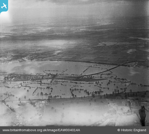
The bridge sitting in the river during the floods of 1947.
The view from the foot of the embankment, looking across the Severn.
'Severn Bridge. Upton on Severn, 7.8.61'
The end of the embankment.
The embankment as it runs back towards Upton.
The old route on its way back to Bury End Farm, south of Upton.
A final view across the Ham at the embankment.

Engineering Drawings


The edition of The Engineer from 7th May 1869 featured detailed engineering diagrams of the bridge. The full issue of the journal can be accessed here (courtesy of Grace's Guides), but I've copied the relevant pages below.